MH370 search faces ridges, canyons and spiralling costs
Frustratingly for search teams in the Indian Ocean west of Australia, Monday passed in silence.
Hopes were high yesterday that a sequence of radio “pings” recorded by Australian search ship ocean shield were from the missing Malaysian Airlines flight MH370.
Relocating the sounds would have allowed the signals to be triangulated, providing the first direct lead to the final resting place of the jet.
But after another day and a half of listening, no further signal has been detected from HMS Ocean Shield in the north of the search area, or from Chinese and British warships searching 300 miles further south.
 A map of the Indian Ocean search area where crews are listening for more radio “pings” from the missing jet
A drop in the frequency of signals found on Sunday suggested the batteries on the locator beacons could be failing — as was predicted.
“There have been no further contacts with any transmission and we need to continue for several days right up to the point at which there’s absolutely no doubt that the batteries will have expired,” according to Air Chief Marshall Angus Houston head of Australia’s joint co-ordination centre.
Robotic submarines are the only tools that could find the plane’s wreckage, given the depths of ocean in the area.
However, the subs are slow-moving and still have a search area the size of Northern Ireland to cover.
 3D profile of the ocean floor
It was announced today that they won’t be deployed until more effort has been made to narrow the search area by listening for more “pings”.
“If we can get more transmissions we can get a better fix on the ocean floor, which would enable a much more narrowly focused visual search,” said Mr Houston.
So for the time being, ships are being excluded from the search area while the painstaking task of listening continues.
Earlier today aircraft deployed an array of buoys equipped with underwater microphones to a separate part of the search area to listen passively for signals.
Even if the search teams do hear more signals, it could be challenging to triangulate the position of their source.
These high-resolution images of the sea bed in the search area show a complex terrain.
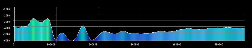 Bathymetric profile of the sea bed between Batavia Ridge and Zenith Plateau, where teams are looking for MH370
There are submarine peaks 2.5km from the surface – but also a deep canyon 6km deep running through the search area. Poignantly, many are named after shipwrecks, the maritime disasters of the past: “Lost Dutchman Ridge” and “Batavia Rise”.
Not only will that sub-sea topography scatter sound around – it could also make it harder for subsequent sonar surveys to find any wreckage.
At what cost?
As the search enters its 33rd day estimates of the cost of the international operation have started to emerge.
Estimates from Australian sources suggest keeping 12 aircraft flying sorties of up to 10 hours each could be costing the country more than 500,000 Australian dollars a day.
Keeping two of their naval vessels in the Indian Ocean for the search is estimated to have cost more than 5 million Australian dollars.
A spokesman for the US Navy told Channel 4 News it had spent nearly $6m on ships and aircraft as well as deploying its pinger locator equipment and robotic search sub to the Australian search.
Follow @TomClarkeC4 on Twitter.